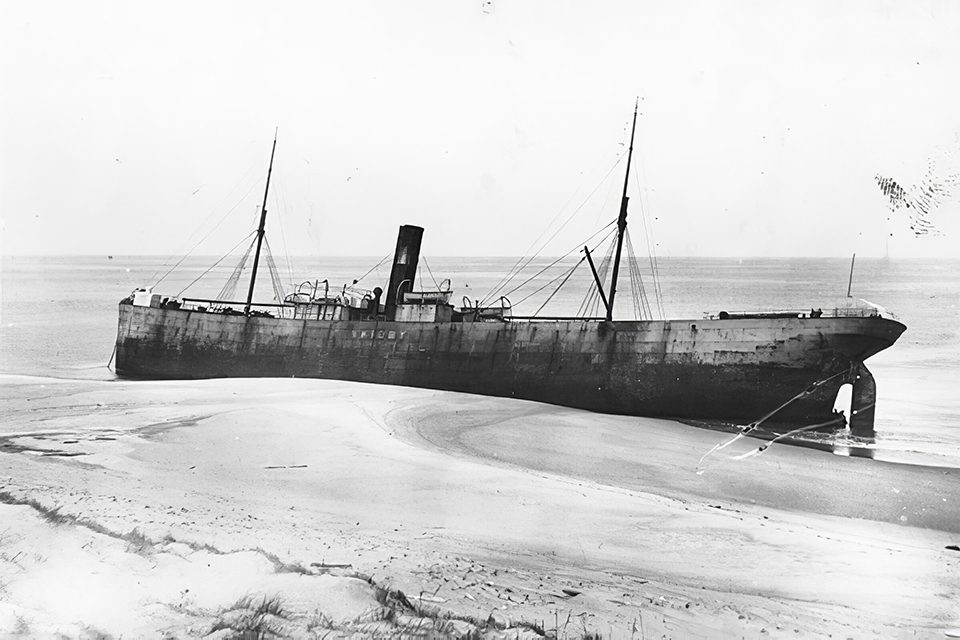
Post on topic: Geographic Mysteries.
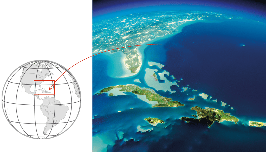
The Bermuda Triangle
🌎 ATLANTIC OCEAN
⚠️ DIFFICULT NAVIGATION, DISAPPEARANCE
The story of the most famous urban legend began in the early 16th century when the Spanish navigator Juan de Bermúdez traveled across the Atlantic Ocean and discovered a previously unknown archipelago. The sea around the islands was teeming with dangerous reefs and shoals, and frightening cries of unfamiliar birds could be heard from the land and a storm raged in the sky. The place came to be known to Europeans as “Devil’s Island” — a nickname perhaps coined by Bermúdez himself. The colonists, understandably, did not take a liking to this name, so the islands were ultimately called the Islands of Bermuda.
Journalists sounded the alarm in the mid-20th century — it turned out that, over the past centuries, many ships had disappeared around Bermuda. The anomalously dangerous zone could even be pinned down: people, aircraft, and ships were said to have disappeared exclusively inside an imaginary triangle bounded by Miami, Bermuda, and Puerto Rico.
Some were quick to attribute the events to paranormal activity, blaming aliens, black holes, and the inhabitants of the legendary sunken island of Atlantis.
Geographic Mysteries: The Origins and Legends of the Bermuda Triangle
The story of the most famous urban legend began in the early 16th century when the Spanish navigator Juan de Bermúdez traveled across the Atlantic Ocean and discovered a previously unknown archipelago. The sea around the islands was teeming with dangerous reefs and shoals, and frightening cries of unfamiliar birds could be heard from the land and a storm raged in the sky. The place came to be known to Europeans as “Devil’s Island” — a nickname perhaps coined by Bermúdez himself. The colonists, understandably, did not take a liking to this name, so the islands were ultimately called the Islands of Bermuda.
Journalists sounded the alarm in the mid-20th century — it turned out that, over the past centuries, many ships had disappeared around Bermuda. The anomalously dangerous zone could even be pinned down: people, aircraft, and ships were said to have disappeared exclusively inside an imaginary triangle bounded by Miami, Bermuda, and Puerto Rico.
Some were quick to attribute the events to paranormal activity, blaming aliens, black holes, and the inhabitants of the legendary sunken island of Atlantis.
Geographic Mysteries: Rational Explanations for the Bermuda Triangle
However, common sense dictates a much more likely explanation. Navigation in the area was very, very difficult for the 16th century Bermúdez and modern ships alike. Should we really be surprised that rocks and storms sometimes lead to crashes and wrecks?
                                    <figure>
                                    <img width="800" height="370" src="https://oyla.us/wp-content/uploads/2023/11/img02-1024x474.png" alt="Geographic Mysteries | A group of rock formations in the water." srcset="https://i0.wp.com/oyla.us/wp-content/uploads/2023/11/img02.png?resize=1024%2C474&ssl=1 1024w, https://i0.wp.com/oyla.us/wp-content/uploads/2023/11/img02.png?resize=300%2C139&ssl=1 300w, https://i0.wp.com/oyla.us/wp-content/uploads/2023/11/img02.png?resize=768%2C355&ssl=1 768w, https://i0.wp.com/oyla.us/wp-content/uploads/2023/11/img02.png?resize=1200%2C555&ssl=1 1200w, https://i0.wp.com/oyla.us/wp-content/uploads/2023/11/img02.png?w=1508&ssl=1 1508w" sizes="(max-width: 800px) 100vw, 800px" />                                         <figcaption>Tobacco Bay is located in the north of Bermuda in the Atlantic Ocean.
Limestone columns about 15–25 ft high separate the bay from the open ocean.
Nowadays, life is in full swing in the area: cruise ships, cargo vessels, as well as commercial and private aircraft routinely travel through it.
There are other “triangles” — in Lake Michigan and an area in southwestern Vermont, in addition to the Devil’s Sea in the Pacific Ocean. Mysterious disappearances in these spots are widely publicized in the press, but people tend to suddenly disappear elsewhere, too. The ubiquity of such incidents suggests that a likely cause is the fatal combination of unfortunate circumstances and human error.
The US Coast Guard has found no evidence that accidents occur with any greater frequency in the Bermuda Triangle than in any other large, well-traveled area of the ocean.

Death Valley
🌎CALIFORNIA
⚠️ SAILING STONES
Can stones move by themselves? At the bottom of Racetrack Playa, a dry lakebed in the hottest place on Earth, they can. The area in question is located in Death Valley, an area already rife with legends and horror stories. This comes as no shock, as traveling through the valley is extremely dangerous, especially during the summer heat, when a person can lose so much fluid that they need to drink about 3 gal of water a day to survive.
Racetrack Playa, located in the northwest of the valley, is a flat plateau covered with clay that has cracked from the heat. Here you can find large stones that likely rolled down from the nearest hills, some weighing several hundred pounds. Sounds all well and good, except that these stones… creep. More precisely, they mysteriously change their location and leave distinct tracks behind them. When and how this happens has been a mystery for a long time.
Indigenous populations believed the cobblestones to be the souls of the dead that were moved by magic. In the 20th century, scientists took up the matter but found it extremely difficult to study the phenomenon: the stones’ movement could not even be captured on camera!
Solving the Enigma of the Moving Stones
Initially, it was thought that the wind was moving the stones, but experimental results showed that even the strongest air stream could not move a 200-lb stone. Another hypothesis was that the stones were being pushed by a magnetic field, but they did not contain iron in sufficient enough quantities to succumb to such an influence.
The riddle was solved only recently, in the winter of 2013–2014. A group of researchers from several US research institutes, armed with GPS equipment and cameras for single-frame shooting, was able to document the stones’ movement.
                <blockquote>
        <p>
            It turns out that the stones crawl along the arid Death Valley thanks to… ice!
                </blockquote>
                                                <img width="800" height="342" src="https://oyla.us/wp-content/uploads/2023/11/img03-1024x438.png" alt="An image of a deserted landscape with mountains in the background." srcset="https://i0.wp.com/oyla.us/wp-content/uploads/2023/11/img03.png?resize=1024%2C438&ssl=1 1024w, https://i0.wp.com/oyla.us/wp-content/uploads/2023/11/img03.png?resize=300%2C128&ssl=1 300w, https://i0.wp.com/oyla.us/wp-content/uploads/2023/11/img03.png?resize=768%2C329&ssl=1 768w, https://i0.wp.com/oyla.us/wp-content/uploads/2023/11/img03.png?resize=1536%2C657&ssl=1 1536w, https://i0.wp.com/oyla.us/wp-content/uploads/2023/11/img03.png?resize=2048%2C876&ssl=1 2048w, https://i0.wp.com/oyla.us/wp-content/uploads/2023/11/img03.png?resize=1200%2C513&ssl=1 1200w, https://i0.wp.com/oyla.us/wp-content/uploads/2023/11/img03.png?w=1600&ssl=1 1600w" sizes="(max-width: 800px) 100vw, 800px" />
    No greater than ¼ inch in thickness, ice sometimes forms during cold nights in the desert. In the morning, the ice sheets melt and break into separate sheets, which are driven by the wind and meltwater. These ice sheets can carry the stones up to 16.5 ft per minute! And just like that, as the Sun comes out to shine, the ice disappears without a trace.</p>
                                                <img width="800" height="419" src="https://oyla.us/wp-content/uploads/2023/11/map03-1024x536.png" alt="A ship in the water." srcset="https://i0.wp.com/oyla.us/wp-content/uploads/2023/11/map03.png?resize=1024%2C536&ssl=1 1024w, https://i0.wp.com/oyla.us/wp-content/uploads/2023/11/map03.png?resize=300%2C157&ssl=1 300w, https://i0.wp.com/oyla.us/wp-content/uploads/2023/11/map03.png?resize=768%2C402&ssl=1 768w, https://i0.wp.com/oyla.us/wp-content/uploads/2023/11/map03.png?resize=1536%2C804&ssl=1 1536w, https://i0.wp.com/oyla.us/wp-content/uploads/2023/11/map03.png?resize=2048%2C1072&ssl=1 2048w, https://i0.wp.com/oyla.us/wp-content/uploads/2023/11/map03.png?resize=1200%2C628&ssl=1 1200w, https://i0.wp.com/oyla.us/wp-content/uploads/2023/11/map03.png?w=1600&ssl=1 1600w" sizes="(max-width: 800px) 100vw, 800px" />
        <h2>Sable Island</h2>
    <p>🌎ATLANTIC OCEAN
⚠️ DISAPPEARANCES, AN ISLAND “ON THE MOVE”
To the southeast of Canada sits a seemingly harmless island shaped like a thin crescent, 30 mi long and just shy of 1 mi wide. There are no sharp rocks or predatory animals there, so why has it been known to sailors as the “Graveyard of the Atlantic” for centuries?
For starters, there have been more than 350 shipwrecks there since 1583, and these are only the ones we know about. There are several reasons for this, and none of them have anything to do with the paranormal. Firstly, the waters surrounding Sable hide its reefs and shallows, which are difficult to see even in calm waters. In fact, the island is just the tip of a huge sandy “iceberg” that literally sucks in sunken ships. Secondly, good weather is rare: Sable averages at least one hour of fog 125 days per year, and storms are just as frequent. Thirdly, the island lies at the junction of three large ocean currents, so ships are driven into a danger zone. So, why don’t sailors steer clear of such a terrible place? Unfortunately, Sable is not far from one of the world’s richest fishing grounds and a major sea route between Europe and North America.
As if all that wasn’t enough: Sable is also migrating! Its coordinates are never constant because currents form whirlpools around the island, which whisk its sand from the northeast coast to the southwest.
<h3>Geographic Mysteries: The Ever-Shifting Sands of Sable Island</h3>Sable moves about 165 ft a year, which would make any map obsolete, except for those from satellites. Can you imagine what it was like for the superstitious sailors of the past centuries?
Fortunately, with the development of modern navigation aids, you no longer have to fear running into the island unexpectedly. But Sable and its surroundings are still dangerous: for example, a major storm claimed the lives of six fishermen in October 1991. The remains of their ship were thrown onto the shore of the island.

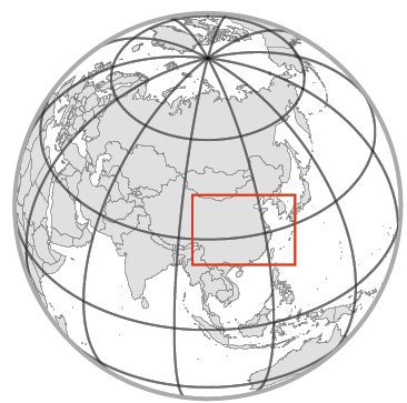
Black bamboo valley
🌎 SICHUAN PROVINCE, CHINA
⚠️ DISAPPEARANCES
When you hear such a name, what do you imagine? An ominous, foggy forest? It’s not surprising that terrible urban legends surround the Heizhu Valley (or Black Bamboo Valley), a picturesque region popular among tourists.
Since ancient times, there have been many stories told about the disappearances of people and livestock in Heizhu. According to legend, in 1949, 30 soldiers disappeared here without a trace. Other tales describe the 1976 discovery of the skeletons of three lost prospectors, and in 1995, the only trace left by two lost soldiers supposedly was their weapons.
Geographic Mysteries: The Legend of China’s Bermuda Triangle
Those who subscribe to the supernatural have another name for this hollow — the Chinese Bermuda Triangle. They point out that the Bermuda Triangle, the Heizhu Valley, and the Egyptian pyramids all have the same latitude. Can it really be just a coincidence? In fact, it’s a bit of a stretch. If you mark these objects on a map, they won’t line up exactly: their coordinates fall between 26 to 28 degrees in latitude.
                                                <img width="800" height="534" src="https://oyla.us/wp-content/uploads/2024/03/bamboo-valley.jpg" alt="A night view of a dense bamboo forest illuminated from below creating a dramatic vertical perspective." />
    As for the disappearances, the valley’s high humidity and consequential ever-present fog are likely to blame. The fog is very dense, so it’s not surprising that people and their pets sometimes lose their way. Rumor has it that the fog is also poisonous, but there’s no scientific evidence to back this up.
                <blockquote>
        <p>
            Many of the mysterious disappearances attributed to Black Bamboo Valley may simply be made up.
                </blockquote>
    For example, in 2016 a 27-year-old hiker, <b>Zou Ming</b>, informed relatives that he was going on a solo trip to Heizhu and promptly set off on a bus to Tibet. To everyone on the outside, it seemed the Chinese Bermuda Triangle had claimed another victim. Ming’s family announced a reward for any helpful information and searched for him for 17 days, only to find him safe and sound in a cozy hotel room. Who knows how many more people have taken advantage of Heizhu’s reputation in order to escape their problems?
                                                <img width="800" height="469" src="https://oyla.us/wp-content/uploads/2024/03/Mapimi-Silent-Zone.png" alt="A composite image showing a geographic location on a globe connected to a landscape photograph of a desert with mountains under a cloudy sky." />
        <h2>Mapimí Silent Zone</h2>
    🌎MAPIMÍ BIOSPHERE RESERVE, MEXICO
⚠️ RADIO SIGNAL MALFUNCTIONS, MUTATIONS
Here we have another place that is often compared to the Bermuda Triangle. Of course, you won’t find ships disappearing in the middle of the Mexican desert, but there are other anomalies: it appears to be exceedingly difficult to pick up a radio or television signal in the Zone of Silence. The legend was born in 1970 when the American test rocket Athena crashed near the Mapimí desert, and the US Air Force sealed off the area. The rocket was found and the wreckage promptly transported away, but from that moment on, urban myths about the desert began to circulate. In addition to poor radio signal reception, giant tortoises with triangle-patterned shells, giants, fallen meteorites, aliens (of course!), and compasses that never point north can supposedly be found in the desert. However, none of these claims have held up under scrutiny.
The Zone of Silence overlaps the Mapimí Biosphere Reserve, whose employees don’t seem to have any problems with their compasses and radios.
<h3>Unveiling the Myths of Mapimí's Zone of Silence</h3>The odd-looking tortoises are, in fact, a rare species of desert tortoise endemic to Mapimí. The myth about giants owes its existence to one particular resident of the Mapimí Biosphere Reserve who just happens to be very, very tall. Ordinary iron-manganese pebbles are sold as meteorite rocks in local shops for tourists.
Visitors often flock to the Zone of Silence to see the supernatural with their own eyes, but they leave disappointed. University of California anthropologist Dr. Andrea Kaus noted that none of the locals that she spoke to had observed strange phenomena in the desert. What they were much more likely to witness were eccentric tourists.
Moreover, the order of these sets of fossils is the same in different places. When Smith decided to classify rock layers based on these sets of fossils (which is why they are called index fossils), it turned out that the vertical sequence of the layers is the same everywhere. He then assumed that layers with the same index fossils were formed at the same time, and he combined layers from several different outcrops in one diagram.
There are still many inexplicable wonders in the world that really do make for great urban legends. However, having exposed the above mysteries with the help of science, perhaps we’ll be able to demystify the rest in due time.

Did you like the post? We invite you to read our other topics in Education category.
Follow us on Instagram.
<svg xmlns="http://www.w3.org/2000/svg" xmlns:xlink="http://www.w3.org/1999/xlink" id="Layer_1" x="0px" y="0px" viewBox="0 0 597.03 475.39" style="enable-background:new 0 0 597.03 475.39;" xml:space="preserve"><style type="text/css"> .st0{clip-path:url(#SVGID_00000021828697454809692600000004318893268413411000_);fill:#54A7B7;}</style><g> <defs> <rect id="SVGID_1_" x="63.22" y="2.39" width="470.59" height="470.65"></rect> </defs> <clipPath id="SVGID_00000125586198135712050590000014503595150480814249_"> <use xlink:href="#SVGID_1_" style="overflow:visible;"></use> </clipPath> <path style="clip-path:url(#SVGID_00000125586198135712050590000014503595150480814249_);fill:#54A7B7;" d="M352.92,237.74 c0-30.06-24.38-54.38-54.38-54.38c-30.06,0-54.38,24.32-54.38,54.38c0,30.01,24.32,54.38,54.38,54.38 C328.54,292.12,352.92,267.74,352.92,237.74 M440.15,237.74c0,78.06-63.55,141.62-141.62,141.62 c-78.12,0-141.62-63.55-141.62-141.62c0-78.12,63.5-141.62,141.62-141.62C376.6,96.12,440.15,159.61,440.15,237.74 M533.83,237.74 c0-129.78-105.58-235.3-235.3-235.3c-129.78,0-235.3,105.52-235.3,235.3s105.52,235.3,235.3,235.3 C428.26,473.03,533.83,367.51,533.83,237.74"></path></g></svg>