STONE CHRONICLE
Post on topic: Geological Periods.
How can we even begin to understand what was happening on our planet millions of years ago? Our main source of information is rock formations that developed during those distant eras. By studying them, geologists can try to reconstruct the conditions that existed at the time of their formation. For example, if a layer of solidified lava or volcanic ash is found, it is evident that a volcano was erupting nearby. A layer of clay suggests that there was a sea, and quite a deep one. In addition, fossilized remains of ancient animals and plants are often preserved in sedimentary rocks, which can be used to restore their appearance.
If we find a place where several different layers are visible one above the other (this is called a geological outcrop), then it is logical to assume that the higher up the layer, the later it was formed.

This method was applied in the 17th century by the Danish scientist Niels Steensen (also known as Nicolaus Stenonius or Nicolas Steno) — today, this idea is called Steno’s law of superposition. Based on it, you can determine the relative age of rocks that are in one place; that is, we can understand which rocks formed earlier and which formed later. However, this does not help us to determine how many millions (or maybe thousands? or billions?) of years ago they appeared: their absolute age.
Geological Periods | Steno’s Laws of Stratigraphy
The Law of Superposition

The Law of Original Horizontality
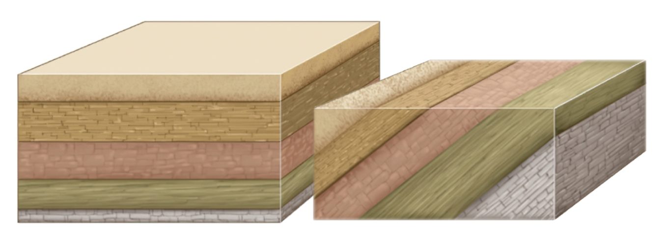
The Law of Lateral Continuity
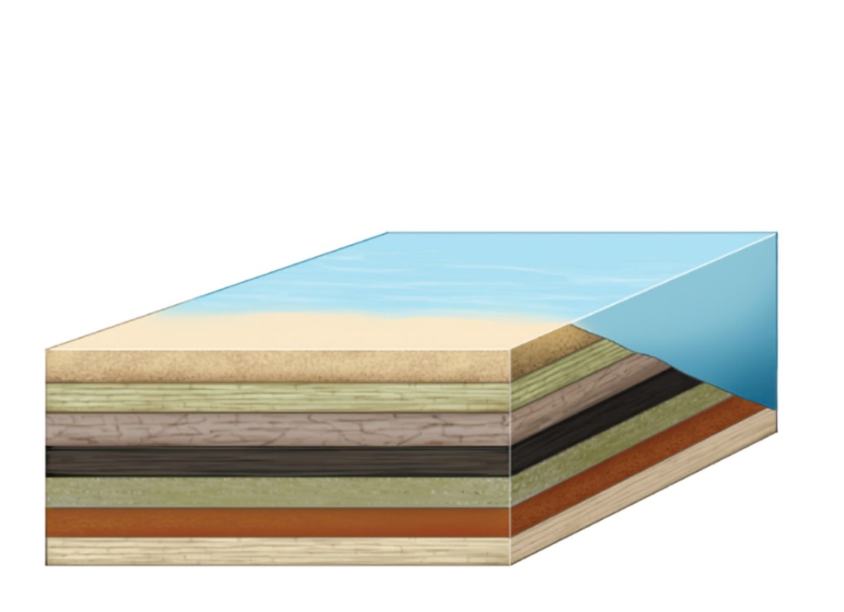
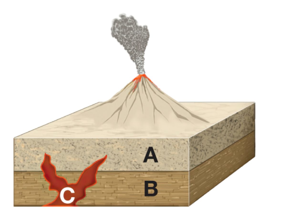
The Law of Cross-Cutting Relationships
Geological Periods | From layers to centuries
Can we compare the ages of rocks from different outcrops? It is clear that if the layers are located close to each other, at a distance of only several miles, then the rocks contained in them will most likely be very similar, if not identical, so it will not be difficult to compare them.
But if the outcrops are located hundreds or thousands of miles from each other, or even on different continents, the rocks in them are likely to be different, and direct comparison will be impossible. A way to solve this problem was proposed in 1799 by the British engineer William Smith.
Consistency of Fossil Sets Across Locations
Working on the construction of canals in different parts of England, he noticed that the findings in rock layers exposed by canal excavations did not occur randomly. Each rock layer is characterized by its own set of fossils — the mineralized remains of organisms and traces of their life activity.
Moreover, the order of these sets of fossils is the same in different places. When Smith decided to classify rock layers based on these sets of fossils (which is why they are called index fossils), it turned out that the vertical sequence of the layers is the same everywhere. He then assumed that layers with the same index fossils were formed at the same time, and he combined layers from several different outcrops in one diagram.
                                    <figure>
                                    <img width="800" height="638" src="https://oyla.us/wp-content/uploads/2023/06/scheme-03.1-3.jpg" alt="Index fossils by which William Smith identified one of the geological layers" />                                            <figcaption>Index fossils by which William Smith identified one of the geological layers</figcaption>
                                    </figure>
                                    <figure>
                                    <img width="800" height="330" src="https://oyla.us/wp-content/uploads/2023/06/diagram-.png" alt="Diagram for building a geological cross-section across multiple outcrops" />                                            <figcaption>Diagram for building a geological cross-section across multiple outcrops</figcaption>
                                    </figure>
    <h3>Creation of the Geologic Time Scale</h3><p>As a result, he obtained a framework for the sequence of layers with the same index fossils (geologists call them <b>strata</b>) — a geologic time scale. Each layer corresponds to the time interval in which it was formed. Based on this finding, Smith made a geologic map of England and Wales in 1815 (this was the first time in history that such a vast territory was mapped by geologists). The map looked very modern: it displayed the distribution of rocks on the surface, with rocks of the same age represented by the same color.</p>
                                    <figure>
                                    <img width="579" height="971" src="https://oyla.us/wp-content/uploads/2023/06/Untitled-1.jpg" alt="1)Sketch of a sequence of layers and their relative heights. 2) William Smith’s geologic map of England and Wales" />                                           <figcaption>1)Sketch of a sequence of layers and their relative heights. 2) William Smith’s geologic map of England and Wales</figcaption>
                                    </figure>
    <p>Over the next two and a half decades, geologists systematized the geologic time scale, identifying large geological layer systems and their corresponding time intervals, <strong>geological</strong> <b>periods</b>. By 1841, almost all the existing periods had been determined. Their names are derived mainly from the names of localities where the corresponding deposits are widespread. Thus, the name of the Devonian Period comes from the County of Devonshire in England; Permian from the city of Perm in Russia; and the Jurassic from the Jura Mountains on the border of Switzerland and France. In some cases, names of characteristic rocks were used.</p>
        <h5>Geological Periods | time scale</h5>
                                    <figure>
                                    <img width="800" height="260" src="https://oyla.us/wp-content/uploads/2023/06/таблица.jpg" alt="The Phanerozoic Eon (which began 541 million years ago and continues to this day) is the largest interval of geologic time. It is famous for its abundance of living organisms, the components of fossils in sedimentary rocks." />                                         <figcaption>The Phanerozoic Eon (which began 541 million years ago and continues to this day) is the largest interval of geologic time. It is famous for its abundance of living organisms, the components of fossils in sedimentary rocks.</figcaption>
                                    </figure>
    <p>For example, there are many coal beds in the Carboniferous deposits, and chalk deposits in the Cretaceous. By the end of the 19th century, the periods were grouped into three eras — the Paleozoic, Mesozoic, and Cenozoic, and divided into smaller parts: epochs and centuries.</p>
        <h2>In search of absolute time</h2>
    <p>However, it remained completely unknown how long ago all these periods took place and how long they lasted. There have been attempts to estimate the rate at which precipitation accumulates in modern seas and, based on this value, to calculate the length of periods during which layers of known depth have accumulated. However, this is a very slow process — usually, over the course of 100 years, not even half an inch is deposited; and in addition, over time, precipitation is strongly compacted (though it was not yet known by how much).
So, this method did not provide us with any reliable data. Therefore, scientists relied mainly on estimates of the total age of the Earth and then tried to calculate the length of each period, assuming that its share in the total history of the Earth is proportional to the share of the corresponding deposits in the combined section. The problem was that it was also impossible to determine the age of the Earth very accurately. For example, in 1868, the British physicist William Thomson (who later received the title of 1st Baron Kelvin for his scientific achievements), based on a mathematical model, suggested that its age is 20-40 million years — during this time, the once-hot planet would have cooled to its present temperature.
This model did not take into account many parameters, so it is not surprising that the result was incorrect — more than a hundred times younger than the current estimate! But until the end of the 19th century, this value was accepted by most scientists. It is clear that the length of geological periods based on this figure were also greatly underestimated.
Geological Periods | The problem of the Precambrian
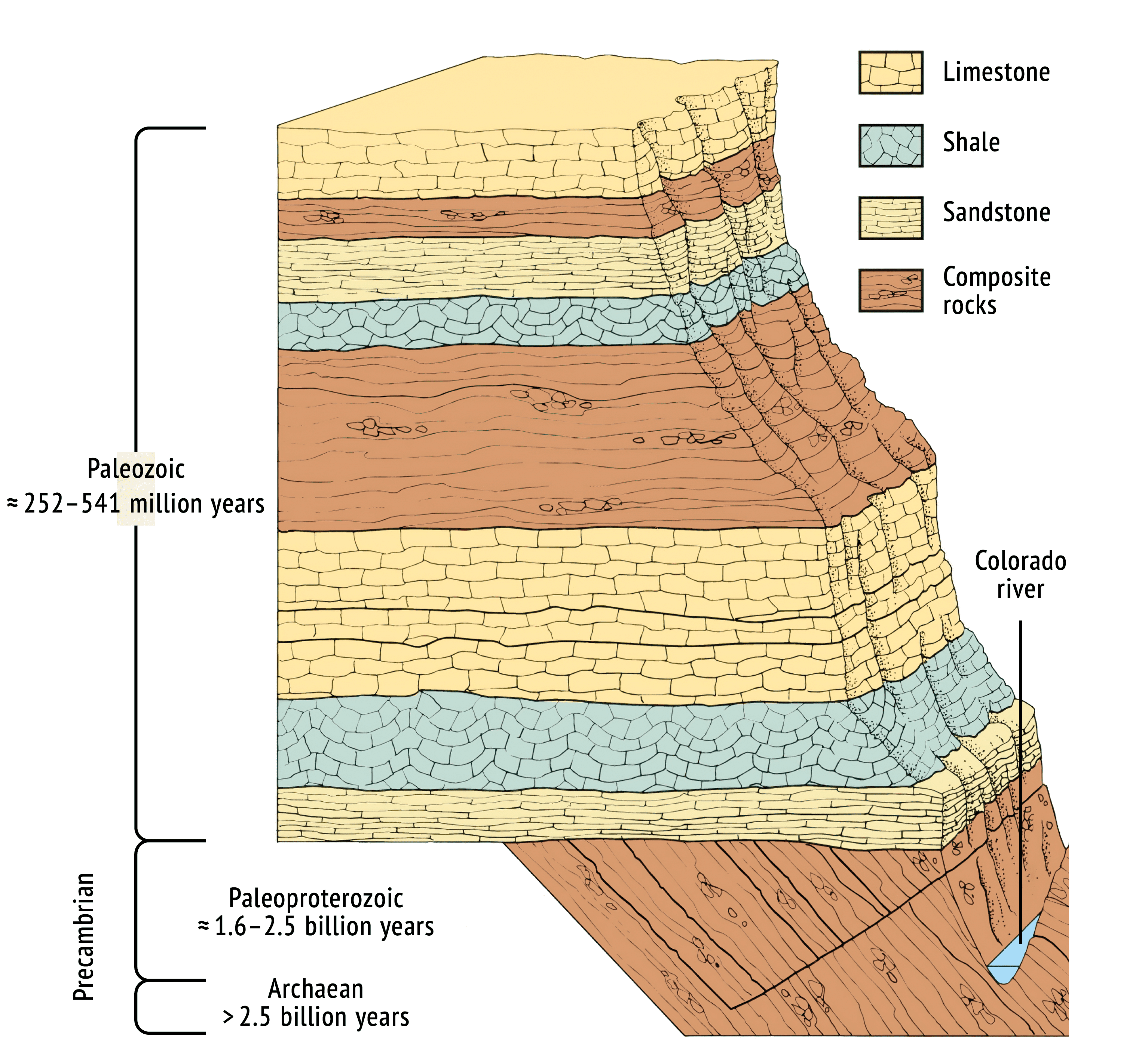
In the 19th century, the geologic time scale was designed only for rocks formed after the Cambrian period, as earlier rocks lacked fossils or traces of life, rendering Smith’s fossil-based method ineffective. In the 20th century, traces of life were found in Precambrian deposits, but these periods are still primarily identified by absolute dating rather than fossils.
The situation changed when the French chemist Henri Becquerel discovered the phenomenon of radioactivity in 1896. In 1904, the British physicist Ernest Rutherford discovered that radioactive isotopes have a certain period of time, independent of external conditions, during which half of their initial amount decays, and he called it the half-life. At the same time, he proposed the idea of radiometric dating. This technique is based on the fact that if a mineral contains a radioactive isotope, by determining the ratio of the mass of this isotope to the mass of the isotope formed as a result of decay, you can calculate the time of formation of the mineral.
Geological Periods | Law of Radioactive Decay

The first experiments in radioisotope dating, conducted independently in 1907 by Rutherford and the American radiochemist Bertram Boltwood, although very inaccurate, still proved that there are minerals on Earth that are at least two billion years old, and therefore the planet itself can be no younger. In the following years, dating technologies further developed, and in 1956, the age of the Earth was determined to be approximately 4.54 billion years — since then, this estimate has not changed much.
Radiometric dating seems ideal for determining the age of Earth and any rocks with radioactive isotopes. However, a rock’s age often differs from its minerals’ age. For example, sand may have been deposited ten thousand years ago, while its quartz grains are millions or billions of years old. Thus, only rocks formed concurrently with their minerals, such as igneous rocks from cooling magma or lava, are suitable for radiometric dating.
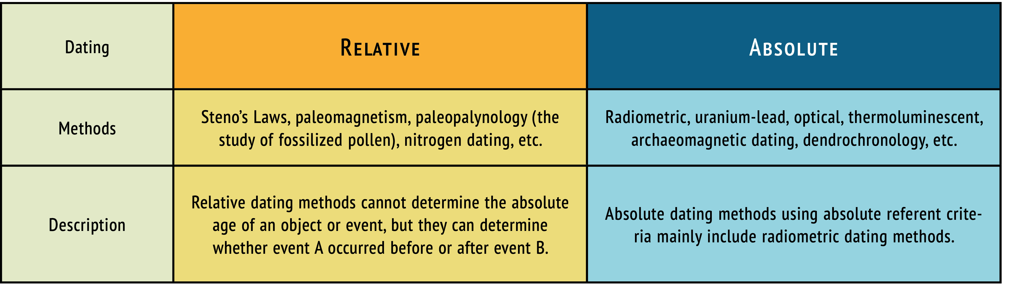
At the same time, the geologic time scale is based, as you already know, on the order of sedimentary rocks. Therefore, geologists usually follow this procedure: find a layer of igneous rock lying between two successive strata of sedimentary rocks and date it, thus determining the absolute age of the boundary between these strata. By now, all borders have been dated using this method, not only between periods but also between the epochs and centuries that make them up. But due to the fact that dating is constantly being refined, geologists still prefer to use relative rather than absolute age.
exact bounder
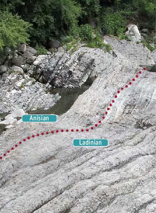
The boundaries between successive strata look slightly different in different outcrops: after all, strata may be composed of different rocks, and the set of fossils varies slightly from place to place. Therefore, geologists agreed to find a section for each boundary between strata in which it would be most noticeable, called the stratotype. When you highlight the boundaries between strata in other outcrops, the stratotype is used as a reference.
Geological Periods | Our epoch
The Quaternary Period began 2.6 million years ago, and it continues to this day. Until recently, geologists divided it into two epochs — the Pleistocene, which covers almost the entire period, and the Holocene, which began only 11,700 years ago. However, in 2016, delegates of the 35th International Geological Congress, held in Cape Town, voted to allocate a new epoch — the Anthropocene.

Their main arguments focused on the sharply-increased impact of human activity on Earth, which is expressed in the mass extinction of species, global climate warming, and environmental pollution, including substances not found on Earth in nature (plastic, aluminum, reinforced concrete). As a marker of the transition to a new era, it was proposed to designate the sharp increase in radioactive isotopes in sediments around the world, associated with the beginning of nuclear testing. Thus, for the beginning of the Anthropocene, you can specify the exact date of reference: July 16, 1945, when the first nuclear bomb was detonated at the Alamogordo test site in New Mexico.
Did you like the post? We invite you to read our other topics in Education category.
Follow us on Instagram.
<svg xmlns="http://www.w3.org/2000/svg" xmlns:xlink="http://www.w3.org/1999/xlink" id="Layer_1" x="0px" y="0px" viewBox="0 0 597.03 475.39" style="enable-background:new 0 0 597.03 475.39;" xml:space="preserve"><style type="text/css"> .st0{clip-path:url(#SVGID_00000021828697454809692600000004318893268413411000_);fill:#54A7B7;}</style><g> <defs> <rect id="SVGID_1_" x="63.22" y="2.39" width="470.59" height="470.65"></rect> </defs> <clipPath id="SVGID_00000125586198135712050590000014503595150480814249_"> <use xlink:href="#SVGID_1_" style="overflow:visible;"></use> </clipPath> <path style="clip-path:url(#SVGID_00000125586198135712050590000014503595150480814249_);fill:#54A7B7;" d="M352.92,237.74 c0-30.06-24.38-54.38-54.38-54.38c-30.06,0-54.38,24.32-54.38,54.38c0,30.01,24.32,54.38,54.38,54.38 C328.54,292.12,352.92,267.74,352.92,237.74 M440.15,237.74c0,78.06-63.55,141.62-141.62,141.62 c-78.12,0-141.62-63.55-141.62-141.62c0-78.12,63.5-141.62,141.62-141.62C376.6,96.12,440.15,159.61,440.15,237.74 M533.83,237.74 c0-129.78-105.58-235.3-235.3-235.3c-129.78,0-235.3,105.52-235.3,235.3s105.52,235.3,235.3,235.3 C428.26,473.03,533.83,367.51,533.83,237.74"></path></g></svg>